Trip Overview
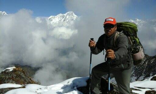 |
| During Langtang trek |
What
it lacks in superlatives – there are no 8000m peaks in the vicinity (unless you
count Shisha Pangma, across the border in Tibet) – it makes up for in
base-to-peak rises that are as dramatic as anywhere. Langtang, in particular,
delivers more amazing views in a short time than any other walk-in trek in
Nepal, with the possible exception of the Annapurna Sanctuary.
Two
distinct basins and an intervening ridge lend their names to the major treks
here; each stands on its own, but given enough time and good weather you can
mix-and-match them. Helambu is closest to Kathmandu, comprising the rugged
north–south valleys and ridges that lie just beyond the northeast rim of the
Kathmandu Valley. North of Helambu, running east–west and tantalizingly close
to the Tibet border, lies the high, alpine Langtang Valley, which in its upper
reaches burrows spectacularly between the Langtang and Jugal Himals. Gosainkund
comprises a chain of sacred lakes nestled in a rugged intermediate range
northwest of Helambu. One practical inconvenience is that the connections
between these three treks aren’t reliable – winter snow may block the passes
between Helambu and the other two – and done on their own, the Langtang and
Gosainkund treks require you to retrace your steps for much of the return
journey.
Food and lodging here are less
luxurious than in the Annapurna and Everest regions, but lodges are mostly
perfectly comfortable. All these routes take you into Langtang National Park. It is Nepal’s first national park, and lies
between the Himalayan range to the north, dominated by Langtang Lirung (7,245
m), the highest peak in the area, and smaller peaks to the south – Chimse Danda
(ridge), Ganja La pass (5,122 m), Jugal Himal and Dorje Lakpa (6,989 m).
 |
The
Langtang Glacier is further up the valley – a long day’s round-trip, as there
are no lodges. From the rocky viewpoint of Langshisha Kharka (4100m), a little
beyond the yak pasture at Numthang, you can see ice and moraine spreading up
the high valleys, hemmed in by snowy peaks. Equally tempting are the ascents of
either Tsergo Ri (4984m), a challenging, 6hr or 7hr round trip that offers an
awesome white wilderness of peaks or Kyanjin Ri (4773m), which stands a mere
two hours or so above Kyanjin Gompa.
You
can return by crossing into Helambu over the Kangja La, but most people go back
down the valley, perhaps varying the last leg by turning off to Thulo Syaphru
(where the trail to Gosainkund branches off) and down to Dhunche.
The trek here is more adventurous as the area is visited by fewer
tourists. Apart from the spectacular scenery, a visit to the area is an
opportunity to explore the lifestyle and culture of the Tamangs, whose
craftsmanship, language, dress and houses bear their uniqueness. Langtang is
also known for its many glaciers – of which there are more than 70 of varying
sizes – and high altitude lakes that include Gosainkunda, Parvatikunda,
Bhairavkunda and Dudhkunda. The forests in the region have temperate and
sub-alpine vegetation. Wildlife includes migratory birds, deer, monkeys, tahr
and pika.
The Langtang River passes through the high, gentle Langtang Valley
before emptying in a raging torrent into the Bhote Kosi River through a long,
narrow defile at the west end of the valley. Whereas the major rivers of Nepal
flow south from Tibet cutting through the Himalayan chain, the Langtang River,
a major tributary of the Trisuli Ganga, flows east to west, cutting, as it
were, across the grain of the country. The Trisuli, or Bhote Kosi as it becomes
above Dhunche, forms an important corridor and ancient trade route through the
mountains between the Ganesh and Langtang Himal, to Kerong in Tibet.
 |
| Camping during Langtang trek |
From either
Dhunche (served by three buses daily from Kathmandu’s Gongabu Bus Park, leaving
in the early morning) or Thulo Syaphru (on the Langtang trek), trails ascend
steeply through mossy rhododendron forest to the monastery and cheese factory
of Sing Gompa at 3250m. The climb from Dhunche is particularly brutal. Above
Sing Gompa, the trail ascends through tall fir stands before emerging above the
tree line for increasingly panoramic views of the high peaks. Laurebinayak is a
beautiful place to stop, before you enter the barren upper reaches of the
Trisuli River, where glacial moraines and rockslides have left a string of some
half-dozen lakes (kund). Several lodges sit by the shore of Gosainkund, the
most sacred of the lakes and renowned among Nepali Hindus. A famous legend
recounts how Shiva, having saved the world by drinking a dangerous poison,
struck this mountainside with his trisul to create the lake and cool his
burning throat. During the full moon of July–August, Janai Purnima, a massive
Hindu pilgrimage is held at Gosainkund.
Two hours
southeast of Gosainkund, you pass over the Laurabina La (4610m), a pass with
superb views, though it can be tricky or impassable in winter due to ice and
snow. You descend towards a very basic lodge at Bera Goth, and an only slightly
better one three hours down from the pass (be sure to follow the low route, not
the dangerous upper one) at Phedi (3630m); this is the usual starting point if
you’re crossing the pass from the southern side. After Gopte (3530m), a hamlet
another three hours on, with yet more basic lodges, you eventually start
ascending again, coming out onto the windy and sometimes snowy ridge at the
settlement of Therapati (3510m). The trail forks here, and you can follow
either side of the Helambu Circuit for two or three days; and the accommodation
is relatively superior. The quicker route is to descend fairly rapidly to the
east, heading to the roadhead at Thimbu via Melamchigaon and Tarkeghyang. The
alternative is to continue south down the ridge for four or five hours, passing
through lovely rhododendron then oak forest via Mangengoth (3390m) to Kutumsang
(2470m), a Sherpa village where the Langtang National Park headquarters is
based. It’s another five switchbacking hours or so on to Chisapani (2251m), a
celebrated viewpoint settlement just beyond the northern edge of Shivapuri
National Park, and another four or five hours up and over from there through
the gorgeously wooded national park to Sundarijal (1460m), from where frequent
buses shuttle to Kathmandu’s Ratna Park (1hr–1hr 30min). There are settlements all the way after Kutumsang, so the walk can be broken
almost wherever you like.
GOSAINKUND can be trekked on its own in as little as four days, but because of the rapid ascent to high elevation – 4610m – it’s best done after acclimatizing in Langtang or Helambu. Combined with either of these, it adds three or four days; a grand tour of all three areas takes sixteen or more days.
Note:- Apart
from Langtang, treks can be arranged to the holy Gosaikunda Lake at 4,380 m,
which covers much of the Langtang National Park, and Helambu. Gosaikunda is
said to have been created by Lord Shiva when He thrust His Trident into a
mountain to draw water to cool his throat after swallowing poison. Thousands of
devotees visit Gosainkunda during Janai Purnima (full moon festival in August).
Helambu

Helambu was once
considered a hidden, sacred domain, and its misty ridges and fertile valleys
are still comparatively isolated; relatively few people trek here, and with so
many trails to choose from, those that do tend to spread themselves out.
Helambu’s people call themselves Sherpa, although they’re only distant cousins
of the Solu-Khumbu stock. Tamangs are also numerous, while the valley bottoms
are farmed mainly by caste Hindus.
Sundarijal, a taxi
or local bus ride from Kathmandu, is the most common starting point, but
alternative trailheads include Sankhu, Kakani and Nagarkot. To get deeper into
the hills faster, take the Arniko Highway to Banepa or Dhulikhel, and change to
one of the fairly frequent buses for Melamchi Bazaar; rough roads head up from
here towards both Thimbu and Sermathang, but are frequently blocked, so
transport all the way is not assured.
Most trekkers make
a five- to seven-day, typically clockwise loop around two main ridges on either
side of the Melamchi Khola, staying high – and avoiding the mega
water-diversion Melamchi Project under construction in the valley. The walk in
follows the Gosainkund trek, rising and falling from Sundarijal through the
Shivapuri National Park to Chisapani, then climbing to Khutumsang and
Tharepati. From here, the circuit breaks east, taking in the fine villages of
Melamchigaon, Tarkeghyang and Sermathang. The walk between the latter two is
somewhat shadowed by a new, rough road, but is otherwise very rewarding,
passing picturesque monasteries and contouring through forests of oak,
rhododendron and lokta, whose bark is used to make traditional paper. From
Sermathang, you can continue down the ridge towards Melamchi Bazaar, though
jeeps (and soon, buses) are available. From Tarkheghyang, the faster
alternative is to take a side trail down to the Melamchi Khola and Melamchi
road at Thimbu (or, failing that, an hour or so below Thimbu) where you can
pick up a jeep down to Melamchi Bazaar. Countless other trails strike west and
east to villages that see few trekkers.
Gosainkund can be
reached from Helambu by a long, high, rugged route from Tharepati, via the
Laurabina La. The higher, still tougher alternative route to Langtang heads
north from Tarkeghyang over the Kangja La (5130m), a serious three-day traverse
for which you’ll need a tent, food, crampons and ice axe (it may be impassable
between Dec and March). From Tarkeghyang, lesser trails cut across the
Indrawati basin and over to Panch Pokahri (3800m), a set of lakes two or three
days to the east, and from there you could continue south to the Chautara road,
which joins the Arniko Highway just above Dolalghat.
KYANGJIN:
Visitors can extend
their stay in Langtang to trek to Kyanjin and explore the upper valley to
Langshisa and beyond.
TAMANG HERITAGE TRAIL:
The
Tamang Heritage Trail takes you through verdant midlands of Nepal experiencing
the beauty of this mountain reigon and the culture of the people who live here.
The trail passes through traditional Tamang villages where life, culture and
crafts have remained unchanged since the beginning of the settlement. The trail
starts eighter from Dhunche or Syabrubesi and passes through Gojng, Gatlang,
Chilime, Thuman, Timure and Briddim. The trail may end back in Saybrubesi or
follow the Lantang trek from Briddim to Kyangjin. For more information on
Tamang Heritage Trail, please look up on the New Products section.
BRIDDIM:
Briddim
(2,229 m) is a small and beautiful Tamang village. It offers Himalayan
cultureal experience in the form o accommodation. About half of the 432 houses
in Briddim offer accommodation at their homes. The village lies on the newly
development Tamang Heritage Trail. For more information on Briddim please look
up on the New Products section.
How:
Starting Point: Pokhara
Max. Altitude:
Grading:
Treaking Seasons:
Mode of Trek: Tea house or Camping
Treaking Seasons:
Mode of Trek: Tea house or Camping
Highlights:
"We welcome you in Nepal for this awesome Langtang Trekking during yours Nepal holidays"
No comments:
Post a Comment